ЗРК «Бук-М1» к катастрофе МН17 не причастен - знала разведка Нидерландов уже в
 diana_mihailova — 18.02.2020


Старая песня, не признает разведка, что знала о наличии бука 17-го
на Донбассе. Они свои попы прикрывают. Если знали, но не
предупредили, соучастники они, если предупредили, но те, кому
доложили, не довели до компаний, значить соучастники те, кому
доложили. Отсюда и вся муть с этими "докладами".
А сделать умный вид и тыкнуть в место на карте, которое невозможно
верифицировать, на это много ума, а тем более каких либо
спецсредств, не надо. Тут главное количество наивных и
проплаченных, которые этому поверят или будут громко рассказывать,
что поверили.
А в радиусе 1400 км таких следов будет немеряно, ищите, хиггинс в помощь.
The table below lists the 9K37M1 Buk-M1 systems (referred to as SA-11A GADFLY by Nato) mentioned in my official notice of 24 June 2015, including their operational status, deployability and distance to the point of impact with flight MH17
9K37M1 Buk-M1 Air Defence Systems present in the region (range 42km).
COUNTRY LOCATION DATE 2014 DISTANCE
1 Ukraine 48°36’38.00″N 39°14’00.00″E No 67 km
2 Ukraine 48°5’58.00″N 37°45’13.00″E No 66 km
3 Ukraine 47° 6’25.00″N 37°28’28.00″E No 135 km
4 Ukraine 45°13’11.00″N 33°22’42.00″E June + July 515 km
5 Ukraine 49° 0’34.00″N 37°18’42.00″E June + July 137 km
6 Ukraine 48°42’23.00″N 37°38’1.00″E June + July 98 km
7 Ukraine 48°13’14.00″N 36° 1’20.00″E June + July 191 km
8 Ukraine 47°58’12.00″N 36°34’26.00″E June + July 154 km
9 Russia 48°44’14.00″N 40° 1’36.00″E 11 – 19 July 122 km
10 Russia 48°38’54.00″N 39°50’18.00″E From 18 July 106 km
11 Russia 48°17’51.00″N 40° 4’42.00″E From 20 July 108 km
From the table it becomes apparent that flight MH17 was flying beyond the range of all identified and operational Ukrainian and Russian locations where 9K37M1 Buk M1 systems were deployed.
In view of the locations of the systems identified and the speed with which these can be moved, as well as the nature, development and conflict and border zone of the fight against the separatists on July 2014 it is unlikely that a 9A310M1 launch vehicle originating from the Ukrainian armed forces could have been moved in time for flight MH17 to come within its range and be hit.
All operational Ukrainian S-300PS Volkov-M6 identified were at least 250 kms away from the point were MH17 was hit. The S-300PS Volkov-M6 system has a maximum range of 75kms. On this basis MIVD draws the conclusion that S-300PS Volkhov-M6 system was not used for the downing of flight MH17.
The only operational system identified with a range wide enough to
shoot down flight MH17 concerned two Russian S-300PM2 Favorit
systems near the Russian town of Rostov na Donu. MIVD does have
(partner) information that would indicate the use of the 36N85
(referred to as TOMB STONE by NATO) fire control radar for the
guidance of and/or launch of a surface-to-air missile from the 48NS
series (referred to as GARGOYLE by NATO) on 17 July 2014.
These locations are in the immediate vicinity of large population
centres and the launch of a missile would most likely have led to
messages on social media or other public media. MIVD is not aware
of such publications.
By order of the
THE MINISTER OF DEFENCE
The Director of the Military Intelligence and Security Service
O. Eichelsheim
Major general
End of Official Notice.
Plotting the given coordinates of eleven locations on a map gives this result:
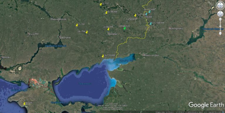
Green pin : crash site Grabovo
Yellow pins: Ukrainian Buk M1 locations according to MIVD.
Blue pins : Russian Buk M1 locations according to MIVD.
Yellow line : Border Ukraine – Russia
One of the conclusions that can be drawn from this Official Notice
by the Dutch Military Intelligence and Security Service is that on
the basis of sources it considers reliable it “becomes apparent
that flight MH17 was flying beyond the range of all identified and
operational Ukrainian and Russian locations where 9K37M1 Buk M1
systems were deployed.”
The main conclusion: the Dutch Military Intelligence and Security
Service on 21 September 2016 (ONE WEEK before the JIT
press-conference on 28th September 2016!) had no information from
any reliable source that any Russian Buk-M1 had crossed the border
with Ukraine during any time during the conflict.
How is that possible?
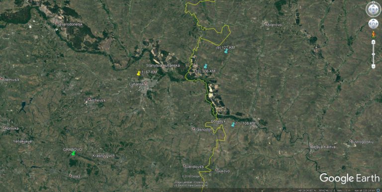
When we zoom in on the map and look at the three locations (blue
pins) of Russian Buk-M1 we notice these three locations are not
only too far from the crash site, but even on the Russian side of
the border.
Now let’s have a closer look at Location (10) 48°38’54.00″N
39°50’18.00″E where according to MIVD a Buk-M1 was stationed 18
July 2014 and onwards is only 6,8km from the border with
Ukraine.
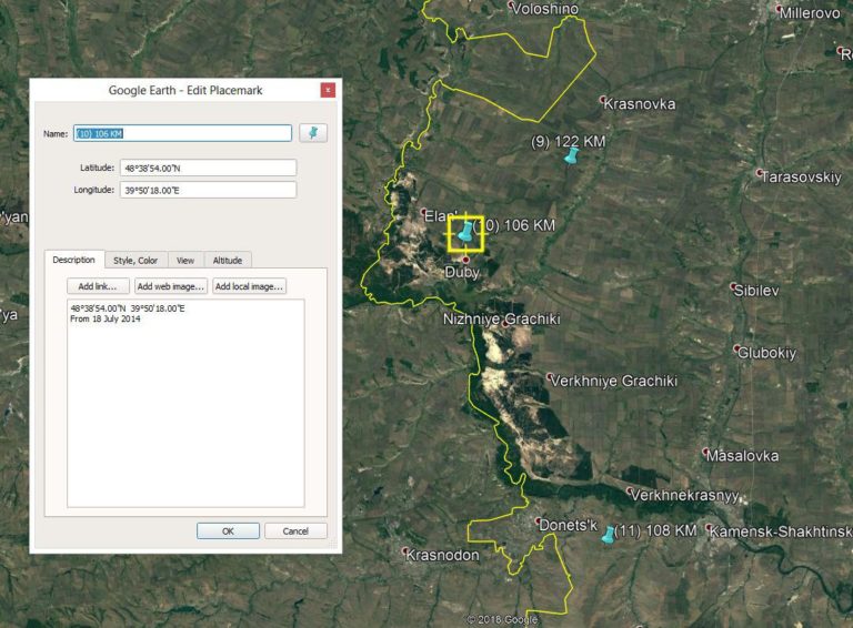
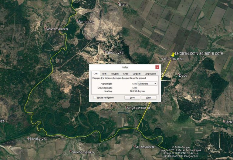
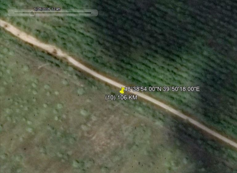
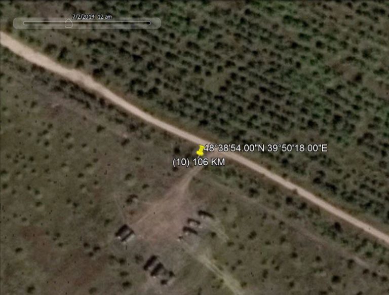
Google Earth has limited options to chose satellite images by date. We checked this location and four different dates showed:
28 June 2014 – no vehicles
2 July 2014 – 8 vehicles visible
17 July 2014 – no vehicles
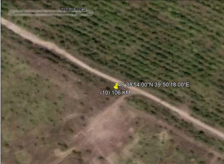
25 July 2014 – no vehicles
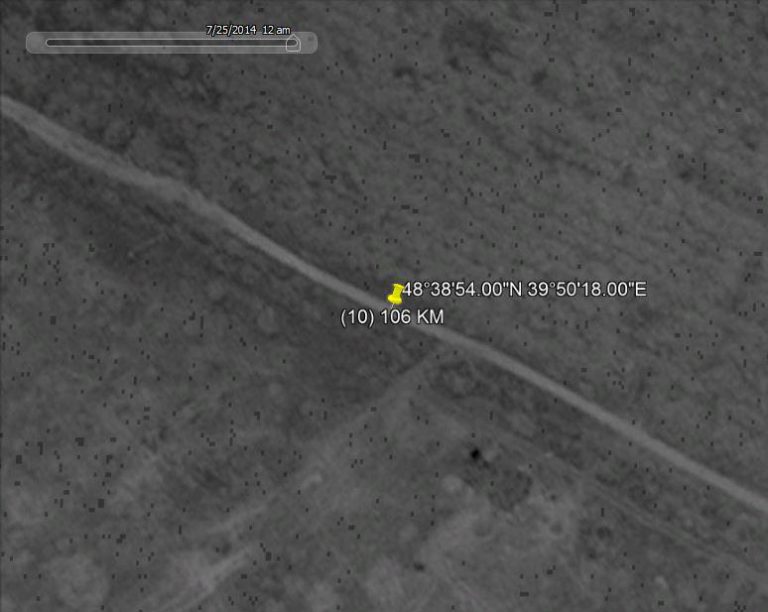
No Google Earth data for 18 July 2014 is available for this
location.

Текст записи интервью журналиста Billy Six и офицера Австралийской Федеральной полиции, сделанной за день
DOC 2. OPERATION AVENELLA


Проверенные экспертами фотографии ЗРК «Бук-М1» в Снежгном и Донецке имеют признаки манипуляций при дополнительной обработке.
DOC 3. WITNESS TESTIMONY (refuting the claim Ukrainian Air Force did not fly)

Показания свидетелей о присутствиии 17 июля 2014 г. в небе в районе катастрофы не менее двух реактивных истребителей до падения МН17.
|
|
</> |


 Полиэтилен низкой плотности: невидимый герой упаковочной индустрии
  Праздничное
  спок
спок  Культурный четверг
  Чего только не увидишь на улицах Будапешта
  Кулинарное
  Одна картинка про минувший день
  Вечернее
  1950—1960-е гг. Мали. Женские портреты на снимках Мишеля Уэта


